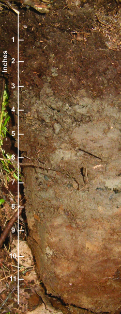
 A soil profile from the site pictured in the photo to the right. The bright red mottling against a gray background at approximately 8 inches in the photo is one indication that the water table comes close to the surface at the site, although the water table was deeper than two feet on 20 July 2007 |
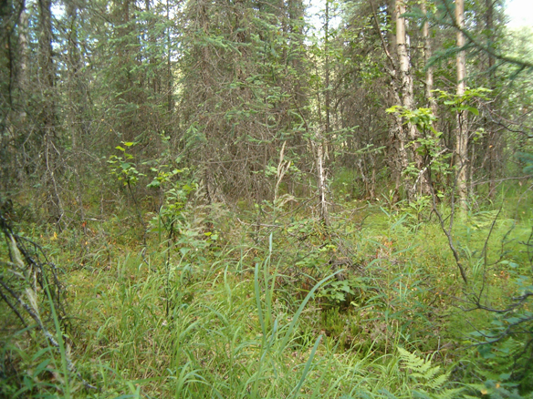 A photograph of the site where the soil profile, left, was described. Some areas of the site were clearly wet, while others were drier. The soil profile was taken at an intermediate postion, and showed that much of the site meets the criteria qualifying it as a wetland although it supported paper birch (Betula papyrifera) |
Range of areas mapped as Wetland/ Upland Complexes
Wetland / Upland Complexes are mapped where at least 30% wetland is present, but at a scale too fine to delineate at the mapping scale (1:24,000 or 1:18,000). At those scales 1/16 inch equals approximately 100 feet. Wetland / Upland complexes may support relatively large areas of upland which are distinctly segregated from small wetlands, or these complexes may be areas at the boundary of wetland conditions, where the water table is not close enough to the surface to qualify the entire site as a wetland under the jurisdiction of section 404 of the Clean Water Act. Wetland / Upland Complexes are mapped in order to draw attention to sites that are wet but which also include areas that are not necessarily wet enough to be under the jurisdiction of section 404. The portions of a wet site where the water table is always two feet beneath the surface for example, may not be jurisdictional but will still present a challenge to a building project.
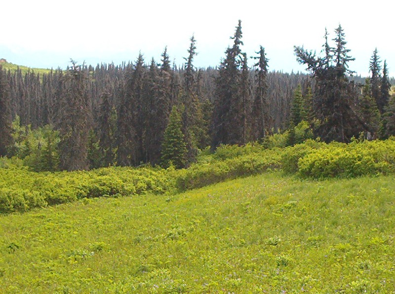
A Wetland / Upland Complex consisting of low, wet areas dominated by willow (Salix barclayi) and spruce (Picea X Lutzii) interspersed with higher areas of open meadow and spruce. The site is located northeast of Homer, near McNeil Canyon
NWI and HGM
The wetland portions of Wetland / Upland Complexes fit into a variety of NWI and Hydrogeomorphic classes. The most common would be classified as forested palustrine wetlands (PFO) in the US Fish and Wildlife Service’s National Wetlands Inventory (NWI), and in the LLWW Hydogeomorphic classification of Tiner (2003) they would be classified as Terrene Slope groundwater-dominated Throughflow wetlands.
Where distinct small wetlands form in areas of high relief, for example in the area along Willow Creek near Peters Creek, the small wetlands are typically Depressions, and these fit into the Palustrine category of the US Fish and Wildlife Service’s National Wetlands Inventory. Depressions support a variety of plant dominants from herbaceous emergents (PEM) to shrubs (PSS) and forest (PFO), with hydrologic regimes ranging from saturated through permanently, semi-permanently, and seasonally flooded (PSSB, PEMH, PEMF and PEMC, respectively).
The LLWW Hydrogeomorphic classification of Tiner (2003) would place Depression wetlands into its Terrene Basin isolated wetland category.
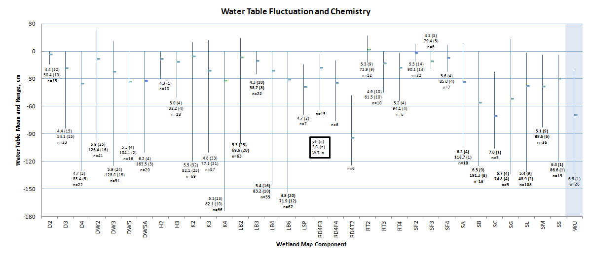
Wetland / Upland Complexes (highlighted in blue) have highly fluctuating water tables, with a mean that is almost the lowest of any component, in part because some sites measured were not wetlands. pH was high at the single site where it was measured, suggesting a predominance of groundwater contributions. Water chemistry was rarely measured because the water table was often too far below the surface when the site was visited. DW = Drainageway, K = Kettle; S = Discharge Slope; LB = Lakebed; SF = Spring Fen; RT = VLD Trough; R= Riparian; H = Headwater Fen; D = Depression.
Wetland Indicators
| Table 1. Wetland Indicators in Wetland/Upland Complexes. | |||||
| Map Component | Peat Depth (cm) | Water Table (cm) | Redox features (cm) | pH | Plant Prevalence Index |
WU |
16 (32) | 70 (26) | 28 (23) | 6.5(1) | 2.66 (28) |
Explanation:
- Numbers in paraentheses indicate number of samples.
- Peat Depth is the thickness of the organic soil horizon.
- Water table depth is a one time measurement. At sites with seasonally variable water tables this measurement reflects both the conditions that year, and the time of year.
- Redox features is the depth to features meeting the criteria for a hydric soil.
- pH was measured in a shallow pit with a YSI 63 meter.
- Plant Prevalence Index calculated based on Alaska indicator status downloaded from the USDA PLANTS database, which may use different values than the 1988 list.
Soils and Plant Communities
Common Soils:
- TUXEDNI
- NIKOLAI
- NIKOLAEVSK
- CHUNILNA
- BELUGA
Common Plant communities:
- Lutz spruce / Barclay willow / Bluejoint
- Lutz spruce / Field horsetail – Bluejoint
- Barclay’s willow / Rich
- Bluejoint – Field horsetail
Wetland / Upland Components:
In the Matanuska-Susitna Valley Wetland / Upland Complexes have been mapped according to the percent area of wetland they support, based on interpretation from aerial photos. All Wetland / Upland Complexes support a wetland area of at least 30%, and if the wetland area exceeds 75% it will be mapped as a wetland in an appropriate category.
- WU: At least 30% of the area is wetland based on interpretation of aerial photographs.
- WU40: Approximately 40% of the area is wetland based on interpretation of aerial photographs.
- WU50: Approximately 50% of the area is wetland based on interpretation of aerial photographs.
- WU60: Approximately 60% of the area is wetland based on interpretation of aerial photographs.
- WU70: Approximately 70% of the area is wetland based on interpretation of aerial photographs.
| Table 3. Summary of Wetland / Upland Complex Map Unit occurrence. WU40, WU50, WU60, & WU70 are only mapped in the Matanuska-Susitna Borough. | ||
| Map Unit | N | Hectares |
| WU | 238 | 7995 |
| WU40 | 4 | 46 |
| WU50 | 5 | 89 |
| WU60 | 7 | 224 |
| WU70 | 5 | 98 |
