On this page you will find useful files for download related to wetland classification and mapping of the Cook Inlet Basin Lowlands, Alaska
ESRI GIS Shapefile
81 Mb .zip file (19 March 2020) contains shapefile, layer and style files, readme, and metadata
Google Earth .kmz
46 Mb .kmz file (19 March 2020) Link to it here from Google Earth Pro on you computer or download it locally or to your Google Drive then display it on your computer or another device using Google Earth Pro or the app. (in Pro on a computer: Add, Network Link or File, Open. On a phone/tablet: Menu, Projects, Open). In Pro, polygons outlined in red have photos linked to them- click on a red polygon and follow the link(s) in the table that pops up. Other links in the table lead to descriptions of wetland types and a wetland FAQ page. MORE INFORMATION
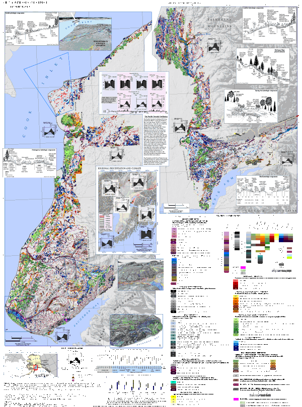
Mapping Poster: Wetlands and Climate of Cook Inlet Lowlands, Alaska
23 Mb .pdf. (4 July 2016). This map sheet is a 36″ x 48″ poster with a legend and descriptions of wetlands on the lowlands of Cook Inlet Basin, Alaska from Kachemak Bay to Denali Park. It includes climate diagrams and diagrams of plant relationships within different wetland types and box plots of water chemistry and water level variability by wetland type. It is the same as one shown in the thumbnail image at the top of this page and the Online Resource in Gracz & Glaser 2016, Wetlands Ecology and Management (DOI:10.1007/s11273-016-9504-0) and Sheet 1 in Gracz MB, 2017. Wetlands of Cook Inlet Basin: Classification and Contributions to Streamflow (Univ. Minnesota Ph.D. dissertation).
Dissertation: Wetlands of Cook Inlet Basin
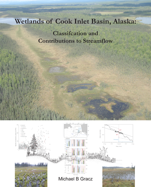
3 Mb .pdf April 2017. The dissertation describes the mapping methodology and wetland types and includes slightly revised versions of the two published papers listed below. The sheet, Mapping Sheet 1, is available as a separate download (23 Mb .pdf 4 July 2016). Hardbound book copies are available that include the 36″ x 48″ mapping sheet. Email Dr. Mike Gracz: gracz016@umn.edu ($30). A must for every natural resource bookshelf in southcentral Alaska and beyond!
It is the best citation for the mapping and work described on this website: Gracz MB. 2017. Wetlands of Cook Inlet Basin, Alaska: Classification and Contributions to Streamflow. PhD Dissertation. University of Minnesota, Minneapolis, MN USA. 128 pp. 1 Sheet.
The dissertation includes slightly updated versions of these two open access publications:
Gracz MB, Glaser PH, 2016. Evaluation of a wetland classification system devised for management in a region with a high cover of peatlands: an example from the Cook Inlet Basin, Alaska. Wetlands Ecology and Management DOI:10.1007/s11273-016-9504-0
Gracz MB, Moffett MF, Siegel DI and Glaser PH, 2015. Analyzing peatland discharge to streams in an Alaska watershed: An integration of end-member mixing analysis and a water balance approach. Journal of Hydrology. https://dx.doi.org/10.1016/j.jhydrol.2015.09.072
Wetland Loss in the Matanuska-Susitna Borough
1.5 Mb .pdf (July 2018) This report quantifies the wetlands filled by type and watershed in an expanded “Core Area” of the Mat-Su Borough. Historic imagery was compared to recent high-resolution imagery and elevation data to delineate all the wetlands that had been filled since the modern era of settlement.
Homer Wetland Complexes and Strategies
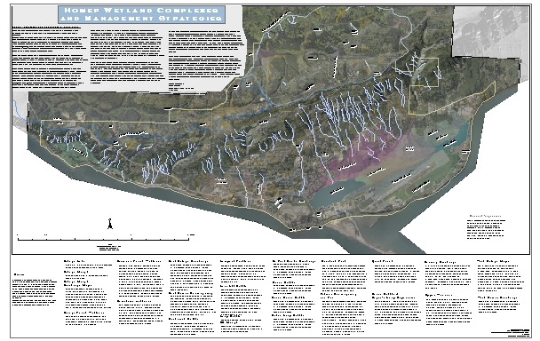
2.4 Mb .pdf.(29 December 2013) This is a 24″x 38″ map poster that defines the wetland complexes in the City of Homer and the describes management strategies associated with each complex. The management strategies should be addressed in an application for a permit to discharge fill into City of Homer wetlands.
