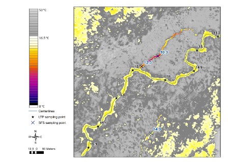
Example above of airborne thermal infrared imagery showing temperature contrast in a stream. A cold water inflow (purple and blue colors) enters the main channel (yellow color). Figure from NV5 Geospatial.
Cold water refugia, or areas within a stream that are persistently colder than surrounding areas, are critical features of wild salmon habitat throughout their range. Stream reaches with cold seeps and springs often result in much cooler water, which are increasingly important for wild salmon to keep cool as water temperatures in many streams have warmed. Some human activities can diminish or extinguish cold water refugia, such as groundwater withdrawal and construction of impervious surfaces. To conserve cold water refugia these sites must first be mapped and identified, and land owners and managers must understand best practices for their conservation.
Since 2020, three community-based organizations – Cook Inletkeeper, Kachemak Heritage Land Trust, and Kenai Watershed Forum – have worked together to identify where cold water refugia are found in the Kenai Peninsula lowlands, a region where productive wild salmon habitat intersects with a growing development footprint. We used cutting-edge methods to locate cold water refugia with thermal infrared imagery, a technology similar to night vision goggles that shows heat contrast. Our resulting “treasure map” of cold water refugia locations is a valuable tool for prioritizing conservation and outreach efforts.