Above: KWF staff use a backpack electrofisher to survey fish habitat in Turnagain Pass, Alaska
Since the early days of Kenai Watershed Forum, we have worked to improve maps of local fish habitat. Good maps are a critical tool for responsible habitat management – we can only hope to have wild fish around for the future if we know where they live today.
Our work has focused on the Anadromous Waters Catalog, which is the Alaska Department of Fish and Game’s inventory of documented waterbodies used by migratory freshwater fish species. Salmon are the most well-known of local “anadromous” fish (i.e., they migrate between freshwater and the ocean), but other important species such as lamprey, steelhead, and others also rely on free-flowing routes between the ocean and their spawning and rearing habitats.
In the Kenai Peninsula Borough, over 4800 miles of streams and rivers are listed as anadromous habitat as of year 2025. Documenting these habitats is a critical conservation and management tool, as documented anadromous habitats can trigger decisions that help maintain healthy habitat to support wild fish populations (such as installing fish-friendly culverts). However when these habitats remain undocumented, they risk oversight and potential damage as communities grow and develop.
In the Kenai region as well as statewide, the challenge of mapping and documenting anadromous habitat is enormous. Staff with the Alaska Department of Fish and Game and other organizations typically identify hundreds of new miles of undocumented habitat each year throughout the state (read more about these efforts here, here, and here). From 2021 – 2024, efforts by Kenai Watershed Forum in partnership with volunteers from the Kenai Peninsula Chapter of Trout Unlimited documented dozens of miles of local streams and lakes right under our noses. While these additions are achievements both for agencies and volunteer efforts, we estimate that still less than 40% of likely anadromous waters throughout the Kenai Peninsula Borough are currently inventoried. The work ahead remains enormous, and without better maps, large swaths of wild fish habitat remain in some senses “invisible”.
But what if there was another way? It turns out, there might be.
While sunny days outdoors working to discover previously-unseen wild fish habitat in our backyards is a great joy for a biologist, replicating that work at the scale of the entire Kenai Peninsula Borough would require countless trips by boat, helicopter, plane, and vehicle, just to arrive at the start of more all-day bushwhacks to survey for anadromous fish. Even then, it’s likely that much habitat would remain unmapped, as our eyes are not always the best judge of the many surprising nooks and crannies where fish can be found across the landscape.
After years of trudging through hip-deep swamps and slogging up mountainsides to look for fish, we started looking in to how researchers in other parts of the country have tackled this kind of challenge. We stumbled across work in progress by the Hoonah Native Forest Partnership in southeast Alaska. There, scientists and community members are working together to develop maps that predict where wild fish habitat is yet to be documented. Using a combination of fieldwork, aerial imagery, and cutting-edge research, they have produced maps that predict fish presence/absence with >98% accuracy within an average of ± 200ft. (Read more about fish habitat mapping in southeast Alaska here).
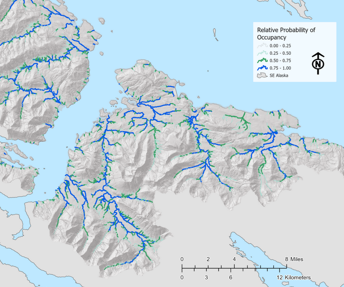
While scientists have previously used predictive maps to help understand the extent of freshwater fish habitat in Alaska, typically the goal of these efforts is simply to assist in guiding fieldwork efforts. These maps are generally much less accurate than the approach developed by the Hoonah Native Forest Partnership, as they are based on remotely-sensed features of the landscape (such as waterfalls or steep rapids) that may or may not reliably predict fish presence/absence.
With the possibility of reliable predictive maps, the goal advances beyond simply prioritizing fieldwork: we can begin to understand and manage aquatic habitat at the scale of whole landscapes, rather than simply what we’re able to access on foot or see with our eyes.
In spring 2025, Kenai Watershed Forum was awarded a federal grant from the National Coastal Resilience Fund to explore if these habitat modeling approaches proven successful in southeast Alaska can be adapted to southcentral Alaska. We are excited to add a host of new partners in addition to all those already mentioned: consultants Romey Riverscape Sciences and Terrainworks, consultants who are providing the technical expertise to help draft these maps and much more. Also, we are privileged to be a part of local nonprofit Cook Inletkeeper’s Local Solutions program, which is bringing community members into the fold for hands-on opportunities to be a part of this work.
Will it be possible to predict presence/absence of anadromous fish with high accuracy for the Kenai Peninsula Borough region? We don’t know yet. We’re just beginning the research process this year and can’t wait to know more. There will always be a trade-off between a map’s accuracy and the expense it took to produce it. The more high-quality data we have, the better our maps will be, and the better opportunity managers will have to balance the needs of fish habitat and developing communities.
We’re off to the races in new and interesting frontiers of science and community collaboration. Subscribe to our newsletter and Cook Inletkeeper’s newsletter to stay informed about volunteer opportunities and more!
In addition to our new support from the National Coastal Resilience Fund, this work would not possible without previous financial support from the Alaska Sustainable Salmon Fund project #54014, Trout Unlimited’s Embrace-a-Stream grant program, the Kenai Peninsula Chapter of Trout Unlimited, and the Kenai Community Foundation. Thank you!
Click Here for Further Reading: Kenai Watershed Forum Works with Volunteers to Document 22.4 miles of Local Salmon Habitat
— Benjamin Meyer, Research Coordinator